The Atlantic ICW northward migration is in full swing, and a lot is happening on the AICW. In my weekly bulletins, I'll cover the hot spots causing the most problems with mariners on their way north.
1 - MM 1033 at Boynton Inlet. The ICW is being dredged, and a dredging barge blocks the ICW channel. Three large sportfish boats went aground 4/4/2025, avoiding the dredge; many others have touched bottom. There have been reports of no response from the barge from hailing on 9, 13, or 16. One boater did get a response on channel 13 with instructions to pass west of the barge. The markings on the barge (pass on the side with diamonds) may or may not be correct. Contact the barge to be sure. The dredge is located at MM 1033.4, south of Lake Worth Inlet and next to Boynton Inlet.

The area is well known for shoals across the ICW channel that can change in depth from 6 to 20 feet in a boat length. It's great news that it's finally being dredged, but in the meantime, take great care in passing the barge. Michael Bell, a Bob423 Surveyor, was instructed to go west of the barge on 4/4/2025 and found shallow water to 4.8 MLLW. He had 0.4 of tide and he squeaked through. His track is shown as a red dotted line in the photo. Again, be sure to contact the barge for the latest advice and go slow.

2 – MM 1004 Jupiter Inlet at ICW crossing has continued to shoal. Depending on your draft, a short track for 4 MLLW is usable at high tide in blue, and a longer track in red is good for 8.8 MLLW as of 4/6/2025. Captains have reported going aground at mid tide with a 5.5 draft boat when taking the shorter track. I would advise the longer track. Both tracks are included in the Bob423 track for the area.

3 – MM 964.8 Fort Pierce channel closures. The North Causeway Bridge is being replaced and the entire width of the ICW channel will be periodically closed for 4 to 6 hours at a time from dawn to dusk during the week. Mariners are advised to call the bridge at least two hours before arriving for opening status for the day. The bridge will operate on normal schedule on weekends and Federal holidays. The closures are scheduled to be in place until May 2, 2024.
An alternate route through the FL A1A Little Jim Bridge will remain open at all times for those who can clear the 14 ft height of the bridge at MHW.

4 - MM 843 at Ponce de Leon Inlet and connecting ICW channel. Dredging equipment may block parts of the ICW channel in this area. You may consider taking the red dotted line detour if the dredge blocks the ICW channel. The detour has never shoaled and is good for 12.7 MLLW as of 4/9/2025. Several captains have reported hitting bottom in the narrow channel by R18A and R18. With a strong ebb or flood tide, a broadside current develops, making it difficult to navigate straight through, not to mention avoiding oncoming boats with little room to maneuver. The straight through shown by the blue dotted line is good for 6.4 MLLW if you can stay on the blue line.

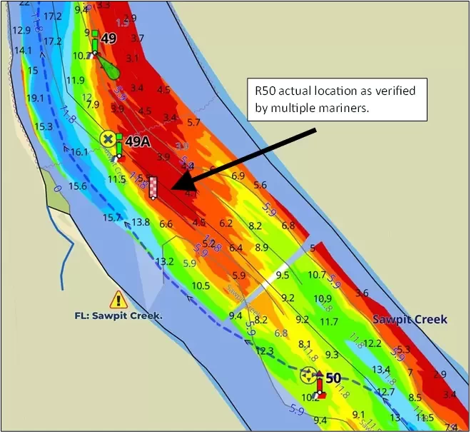
5 – MM 731 Sawpit Creek. ATON R50 is not as charted in the Light List and is located in shallow water. You would run aground if you tried to honor it. Since R50 has been verified to be on a piling, the off-location is not the result of a drifting buoy.
Do not try to honor R50. Two boaters have reported running into shallow water when they tried. Follow the Bob423 track for deep water.
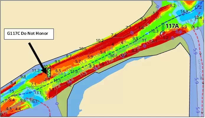
6 – MM 460.2 Isle of Palms has been dredged! At least through the shallow area just south of R117A. There's no longer a need to take the detour route (red dotted line). Follow the NOAA channel with the blue dotted line for 10 MLLW.
Note: As of 4/12/2025, there is an uncharted green floating buoy, G117C, off to the port side of the channel when going north. Its approximate location is shown in the photo. Several boats have grounded trying to honor it. G117C is not on any chart or in the light list, ignore it and follow the middle of the newly dredged channel as shown by the blue dotted line (the latest Bob423 track) in the photo. G117C used to mark the channel before dredging, and it has not been moved after dredging.
7 – 280.2 Mason Inlet. Follow the curving Bob423 track for 6.6 MLLW as of 9/17/2024. Several boats have gone aground trying to go straight through.

8 – MM 244 New River Inlet has been dredged. You no longer have to take the "Dip route". Just follow the blue dotted line for 12 MLLW.
Note: R72A may still be located as shown in the chart below. You can expect the Coast Guard to relocate it to mark the new channel, probably to the other side of the channel opposite G71A.

9 – MM 240.6 Onslow Bridge Construction Continues. The Coast Guard Local Notice to Mariners has expired, but the Onslow Bridge construction schedule continues as verified 4/13/2025 for weekdays only. The normal schedule applies on the weekend and Federal holidays.
• 8:00 to Noon: Height restricted to 12 feet
• Noon to 1:00 pm: No height restriction
• 1:00 pm to 5:00 pm: Height restricted to 12 feet
• 5:00 to 7:00 pm: Opens on top of the hour
• 7:00 pm to 7:50 am the next day: Opens on request
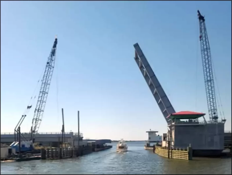
Notes: The new bridge is 14 feet high at MHW. The old bridge is 12 feet at MHW. If you need between 12 to 14 feet, the bridge tender will open the old bridge on top of the hour between 8:00 am to Noon and 1:00 pm to 5:00 pm so you can pass under the 14 foot high new bridge. Construction is expected to continue for at least three more weeks (till May 2, 2025). Contact the bridge tender for additional details at 910-440-7376. The photo looks north, the new bridge is in the foreground, the old bridge is behind it.
Use Waterway Guide Alerts to plan your trip, adjusting timing for the tide you need. Follow the Bob423 tracks in Aqua Map to ensure you get the maximum depth possible. The color-coded depth charts are from USACE surveys in Aqua Map. The areas mentioned in this Bulletin are only the recent changes, not a complete guide to all shoaling. Additional resources are available in the Waterway Guide digital publication 2024 ICW Cruising Guide and at Bob423 Guides.
General information on the attractions of America's waterways can be found at WaterwayGuide.com. Additional publications on all regions can be found at the Ship Store. Many helpful articles are available in the Knowledge Center. Explore the Waterway Site for a wide range of help in your cruising adventures.

- 4,000 Marinas
- Thousands of anchorages
- Updated Charts
- Mile-by-Mile Navigation
- Highlighted Alerts & Cautions
- Full-Color Aerial Photographs
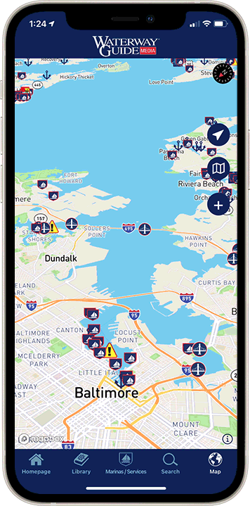
The Waterway Guide App Makes it easy to leave reviews, use our explorer, and view waterway guide materials all on the go!