The placement of a sounder's transducer is usually a foot or more underwater. Most mariners enter an offset to adjust the depth readout at the helm to be either depth under the keel or from the water's surface. In a recent poll on the ICW Cruising Guide Facebook page, the members were evenly split, with a few that had no offset. Regardless of your preference, you should check your helm depth display once a season to be sure it shows what you intended.
The time-honored way of measuring water depths is with a sounding line, which consists of a heavy lead weight with a flat bottom tied to a line with markings for depths. (See an example from West Marine.) The lead weight stops when it encounters a firm bottom and will sink through "mud fluff", mimicking the action of your keel when it hits bottom. For best results, choose a calm day when anchored and lower the sounding line over the side closest to your sounder transducer. Calibrating your depth is less accurate in a marina where the bottom can be shallower near pilings.
Once you accurately know the water's depth, you can then adjust your sounder's offset to display your choice of depth under the keel or depth of the water. Some mariners even add a "safety factor" on top of the offset so a 5 foot readout at the helm is really 5.5 feet. Whatever your preference, it all starts with an accurate depth measurement with a sounding line.

The next step is to enter the offset.
• If you show water depth, then an offset is entered and adjusted until the helm display matches the sounding line measurement.
• If you show water depth under the keel, subtract your keel depth from the sounding line measurement and adjust the offset until that number displays at the helm.
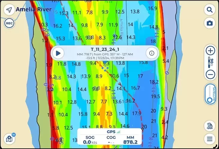
If you have a WiFi gateway that transmits your instrument's readouts over WiFi, your depth will appear in most navigation apps. Aqua Map (shown on the left) and Navionics (now Garmin Boating) will display the depth on the home screen. One advantage of using water depth vs depth under the keel is the ease of trading depths between captains; no adjustments are required for differing keel depths between boats.
The procedure of entering an offset differs between manufacturers.
• For Garmin chartplotters: select Settings > My Vessel > Depth and Anchoring > Keel Offset
• For Raymarine chartplotters: navigate to Setup or Calibration menu > Transducer Setup or Depth offset
• Other chartplotters are similar.
Look to the manual for details if you have a standalone depth display. All depth sounders can be adjusted to show depth of the water, depth under the keel, or anything in between (if you wanted a safety factor).
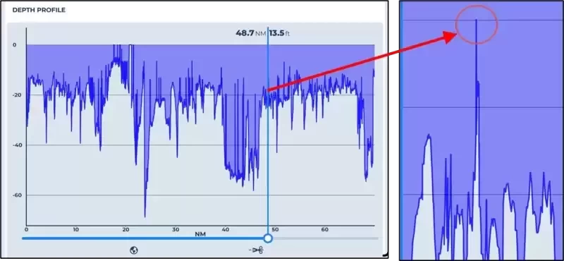
Aqua Map has the capability of recording depths as part of a recorded track. Each track point has a date, time, Lat/Long, and depth if you have a WiFi gateway installed. The depth display at the helm can be whatever you prefer: water depth or water under the keel. However, the recorded depth can still be water level using an internal adjustment in Aqua Map. Sharing tracks with depths is much easier when the depths are always measured from the water surface to channel bottom. Once loaded to Aqua Map, the depths seen in a track can be displayed graphically, and the least depth for a passage through a shallow area can be found. In the example below, Fernandina is shown with the lowest depth tagged with a popup at 13.5 feet.

The shallowest spot was found by using the depth graph from Aqua Map, which displays all the depths recorded in the track. The far right shows the shallowest spot seen in the section for Fernandina at 13.5 feet with 3.8 feet of tide for a total of 9.7 MLLW. 
Now that your depth readings reflect reality, you can share your depths with other captains with confidence. If Aqua Map is connected to a WiFi gateway, you can do better by sharing an entire track with the depths automatically included by date, time, and Lat/Long. Consider joining the ICW Cruising Guide Facebook page where members routinely share depths they see through the many shallow spots of the ICW. More data is better when cruising shoaling waters.
See Bob423 Guides for more information on cruising the ICW and other areas.


